Garmin ActiveCaptain®
- 4.1
- Rating
- 1.00M
- Installs
- Free
- Price
 Analysis by App-foxy
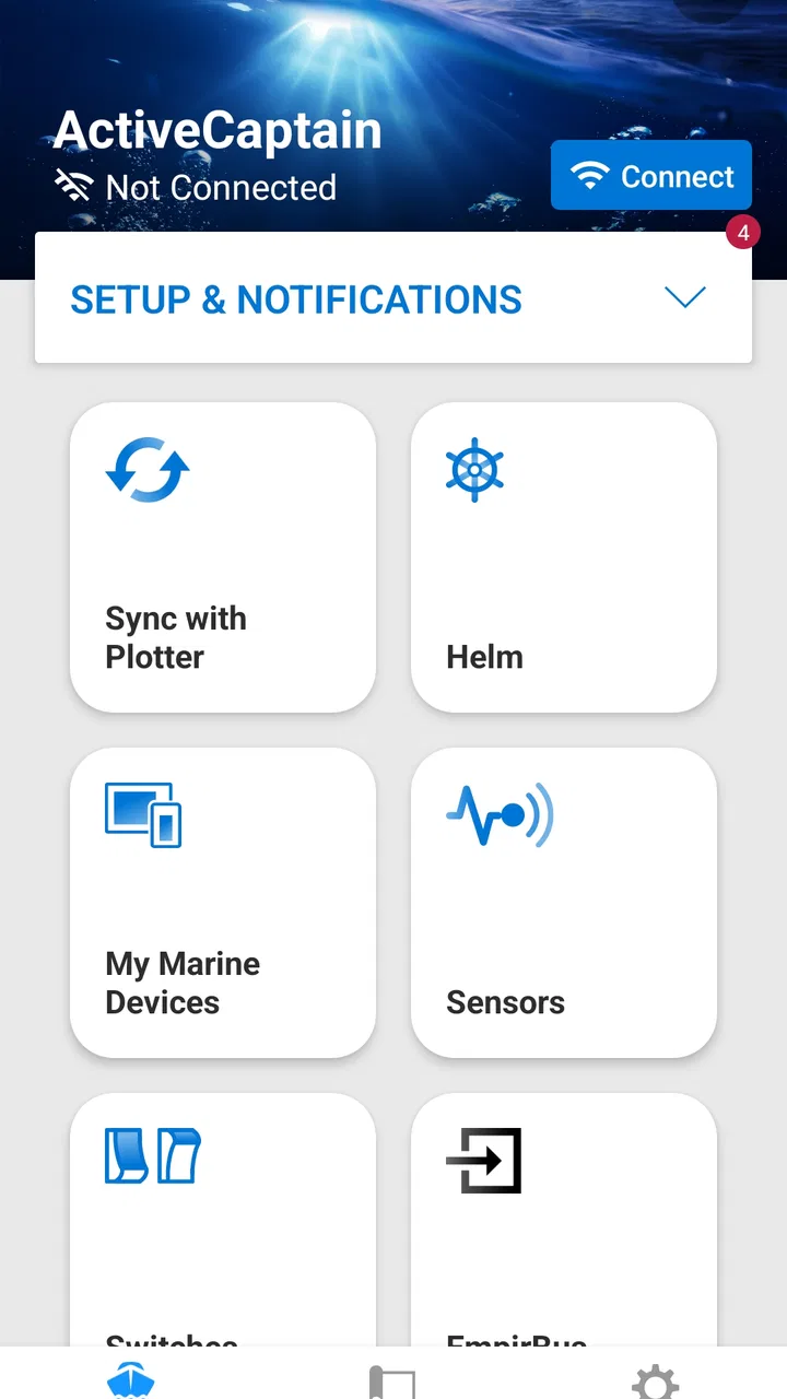
Garmin ActiveCaptain® is the kind of navigation app that makes sense when your phone is part of a larger boating setup rather than a standalone travel tool. I approached it as a companion for a Garmin GPS plotter, and that distinction matters from the first screen: this is not trying to replace every road map or become a general-purpose navigation service. Its purpose is to help a compatible Garmin marine system and a mobile device work together more conveniently.
That focused role is its biggest strength and also the main reason some people may feel disappointed. If you already use Garmin equipment on a boat, the app can put useful connected tasks closer to hand. If you simply want directions for driving, walking, or occasional sightseeing, it is the wrong category entirely. Garmin, the developer, presents it as a connection to your GPS plotter, and my experience of the app is best understood through that relationship.
Where the experience usually gets stuck
The first source of frustration is often not the application itself but the expectation that installing it will immediately create a complete navigation experience. A phone, the app, and a Garmin plotter are separate pieces. They need to recognize one another and operate in the right context. When that connection does not appear, it is easy to assume the app is broken, even though the real issue may be the plotter, the local network, the phone’s connection state, or an incomplete setup step.
You May Also Like

 Blood Strike: 2.5 Anniversary
Blood Strike’s Loadouts Turn Every Drop Into a Tactical Gamble
A close look at Blood Strike’s custom loadouts: how fast access to signature weapons reshapes its battle royale rhythm, rewards preparation, and narrows the gap between fights.

 Pandora - Music & Podcasts
Pandora’s Music Is Easy to Start, but Harder to Recover
Pandora’s strength is its low-effort path from a seed to a station. Its weak spot is how much confidence it asks you to place in connection, setup, and quiet recovery.

 8 Ball Pool
 Is Built on Rivalries, Rematches, and Routine
A close look at the rivalries, rematches, shared routines, and unanswered safety questions that turn a quick pool match into a persistent mobile community.

 Samsung Music
’s Quiet Strength Is Playing What You Already Own
Its reach comes less from spectacle than from dependable access to a personal library. That simplicity is both the app’s strongest retention engine and its ceiling.

 AccuWeather: Weather Radar
AccuWeather Review: A Quick, Clear Forecast for Everyday Decisions
For everyday plans, the best forecast is the one you can understand quickly. AccuWeather makes rain timing, radar, and local conditions easy to act on, with a few trade-offs.

 Hill Climb Racing
Why Hill Climb Racing Still Turns Crashes Into One More Run
A tiny car, a bumpy hill and one more upgrade: Hill Climb Racing keeps resurfacing because its simple chaos makes every near-miss feel personal.
More From Our News Desk



I would therefore begin with a simple question: do you own and actively use a compatible Garmin marine display? If the answer is no, the app has little reason to remain installed. It is not a general replacement for a normal map application, and its value does not come from browsing streets or planning a daily commute. Its value comes from extending a Garmin boating workflow onto a mobile screen.
Another common sticking point is trying to do too much while the boat is already moving. Connecting devices, checking settings, and learning the interface are much easier at the dock than during a busy departure. A calm setup session lets you see whether the phone can find the plotter, whether the correct device is selected, and whether the information you expect is actually available. Doing this before leaving also avoids turning a small pairing problem into a navigation distraction.
The app has a broad audience in the store: it is free, rated for Everyone, and has passed the one-million-install mark. Those details make it easy to try, but they should not be mistaken for proof that it will be useful without Garmin hardware. The average rating of 4.1 suggests a generally positive reception with some room for friction, which matches the nature of a connected utility: it can work very well when the surrounding equipment and setup are right, but it is less forgiving when they are not.
What I check before blaming the app
My first check is physical and practical. Is the plotter powered on and fully ready, rather than merely receiving power? Is the phone close enough to communicate reliably? Is the phone connected in the way the Garmin system expects? I also close unrelated connection-heavy apps temporarily, because reducing variables makes it much easier to identify which part of the chain is failing.
I then look at the app’s device view without repeatedly tapping every option. Repeated attempts can make a simple issue harder to understand. A better approach is to note exactly what happens: does the plotter never appear, does it appear but fail to connect, or does it connect and then lose the session? Each symptom points to a different area. That small habit is one of the most useful troubleshooting improvements because it turns vague frustration into a sequence that can be tested.
It is also worth checking whether the phone is using the account or device context you intended. Connected marine apps can feel confusing when a household has more than one Garmin unit or when a phone has previously been paired with another system. I would remove old assumptions from the process and identify the current plotter deliberately instead of accepting the first device name that looks familiar.
Keep the app and the plotter close to one another during the initial test. A connection that works beside the console but fails from a different part of the boat may be revealing a range or interference problem rather than an application defect. This is especially important when the phone is being used below deck or behind equipment that weakens the local connection.
Setup checks that save time later
The best setup is boring. I install the app before the trip, power the Garmin system in a stationary place, and allow enough time to confirm that the devices recognize each other. I also make sure the phone has enough battery for the intended outing. A phone that shuts down halfway through a connected workflow is not an app failure, but it can leave the user feeling that the whole system is unreliable.
During setup, I pay attention to the order in which devices become available. Turning on the plotter, waiting for it to finish starting, and then opening the app gives the connection a clean chance to form. If I launch everything at once, I cannot easily tell whether the app missed a device that was not ready yet. This is a small operational detail, but it is more useful than endlessly reinstalling the application.
I would also test the exact task I plan to use later. Seeing a device name is not the same as confirming that the intended connected workflow functions correctly. If the goal is to use the phone alongside the plotter, I check that relationship while still at the dock. If the goal is simply to inspect information away from the helm, I verify that the app shows what I expect before depending on it.
The current version is 42.0.3266, and the app requires a device running at least Android 10. That operating-system requirement is important for older phones: installation compatibility is not the same as a smooth experience, particularly on a device that is already struggling with battery life, wireless connections, or background activity. I would update the phone through its normal system process and then test again, rather than assuming the newest app version can compensate for an aging handset.
One practical trade-off is that a phone is convenient but not automatically the best primary screen on a boat. Glare, wet fingers, a protective case, and the need to keep attention on the surroundings can all make a small mobile display less comfortable than the plotter at the helm. I see ActiveCaptain as a companion that can reduce trips back to the console or make certain checks more convenient, not as a reason to ignore the dedicated navigation equipment.
Recovering the workflow when a connection fails
When the app stops behaving as expected, I use a controlled reset rather than changing several things at once. First I stop the current attempt, return the phone and plotter to a stable state, and try again with both devices nearby. If that does not help, I restart the app. Only after observing the same problem again would I restart the phone or the plotter. This sequence protects the useful clue: if everything is rebooted immediately, it becomes harder to know what solved the issue.
There is a difference between a one-time discovery delay and a repeatable connection failure. I give the first attempt a moment, especially after powering on the marine system, but I do not keep waiting indefinitely. If the device appears and disappears, I move the phone closer and reduce other wireless activity. If the device never appears at all, I return to the basic checks: correct plotter, correct phone connection, current software, and a setup performed while stationary.
A useful recovery habit is to write down the last action that worked. For example, if the app connected successfully before the phone changed networks or the plotter was powered down, that detail gives the next attempt a starting point. If the problem only occurs after leaving the dock, the environment deserves more attention than the installation. If it happens beside the powered plotter every time, the pairing or device configuration deserves attention first.
I would avoid treating reinstalling as the universal fix. Reinstallation can clear a damaged local state, but it can also remove a configuration that was useful for diagnosing the problem. I try the less disruptive steps first: close and reopen the app, confirm the device is ready, move closer, and repeat the connection under the same conditions. If the issue remains, a clean reinstall becomes more reasonable, followed by a fresh setup rather than restoring every old assumption immediately.
This app is also a good example of why a connected tool should not be the only thing you rely on while underway. Even when the software is working, the phone can lose power, become wet, overheat, or leave the useful connection area. I would keep the Garmin plotter as the primary navigation reference and use the mobile app to complement it. That is not a criticism of ActiveCaptain; it is the sensible division of responsibility between a dedicated marine display and a general-purpose phone.
When the app is not the cause
Some apparent failures come from the wider environment. A plotter that has not completed its own startup, a phone with aggressive battery management, a weak local connection, or an incorrect device selection can all look like an app problem. The fastest way to separate these causes is to change only one condition at a time. Move closer, keep the plotter stationary and powered, or try the same phone with the same device after a clean restart. The result is more informative than a long list of random fixes.
Battery-saving behavior deserves particular attention. A phone may limit an app that is not currently visible, especially when the screen turns off. I would test the workflow with the application open and the phone awake before deciding that the connection is unstable. If the session works only while the app is in front, that may be a limitation of the phone’s background handling rather than a fault in Garmin’s software.
Likewise, a boat is not a laboratory. Metal structures, enclosed spaces, nearby wireless equipment, and distance between the helm and the phone can change the result. If the app works reliably beside the plotter but not from a cabin, I would treat that as an environmental limitation and adjust the phone’s position. Expecting identical performance everywhere on board is less realistic than finding a practical place where the connection remains dependable.
There is also a human factor. If more than one person uses the boat, each person may open the app with a different phone state or expect a different Garmin device. Clear naming and a consistent setup routine prevent many avoidable mistakes. I prefer one person to perform the initial pairing and then explain the everyday workflow to others. That creates a known baseline instead of several competing configurations.
Compared with ordinary navigation alternatives, ActiveCaptain is deliberately narrower. A standard map app is better for roads, addresses, traffic, walking routes, and casual location searches. A general boating application may be preferable for someone who wants a broad charting experience without being tied to a particular plotter ecosystem. Garmin’s app makes more sense when the dedicated Garmin equipment is already central to the boat and the user wants a mobile companion rather than another independent navigation platform.
That ecosystem focus can be a benefit for an existing Garmin owner because fewer tools need to be mentally separated. It can also be a limitation for someone who changes equipment often or wants one app to serve several brands. I would not choose this application solely because it is free. The meaningful question is whether its connection to your Garmin plotter solves a real problem in your routine.
A realistic day on the water
Imagine preparing for a short morning trip. Before leaving the dock, I power the plotter, open the app, and confirm that the phone recognizes the intended system. I keep the phone near the console while checking the connected workflow I plan to use, then put it where the screen is readable without taking attention away from the surroundings. If the app does not connect, I solve that before departure rather than improvising once the boat is moving.
Later, if the phone loses contact, I do not immediately assume that the route or marine equipment has failed. I bring the phone closer, check whether it has gone into a restrictive battery state, and look at whether the plotter is still operating normally. If the dedicated display remains stable, I continue using it as the primary reference and treat the phone connection as something to restore when convenient. This keeps a minor software interruption from becoming a safety distraction.
That scenario shows where the app earns its place. It is useful when the phone adds flexibility around an existing Garmin setup, especially before departure and during low-pressure checks. It is less convincing when the user expects a phone alone to provide the complete experience. The app’s usefulness is therefore situational, but the situation is clear enough to judge before installing it.
Who should use it and who should skip it
I would recommend Garmin ActiveCaptain® to a Garmin plotter owner who wants a mobile companion and is willing to spend a few minutes establishing a dependable routine. It is also a reasonable choice for a boat owner who prefers to test connected functions at home or at the dock instead of discovering setup problems during a trip. The free price lowers the barrier to trying it, while the Everyone content rating makes it suitable for a broad household audience.
I would skip it if I need a standalone road-navigation app, a universal marine tool independent of hardware, or a simple map for occasional outdoor use. I would also hesitate if my phone is too old for Android 10, has unreliable wireless behavior, or is already overloaded with battery and storage problems. In those cases, the app may add another point of friction without addressing the real need.
My final view is positive but specific: this is a focused companion, not an all-purpose navigator. Its strongest quality is the way it can fit into a Garmin-centered boating routine when the setup is done carefully. Its weakest point is the number of conditions involved in making that routine feel effortless. If you check the hardware first, test the connection while stationary, recover failures methodically, and keep the plotter as the primary reference, the app is worth trying. If you do not own the Garmin equipment it is designed to accompany, a more independent navigation alternative will almost certainly serve you better.
With over six thousand ratings and hundreds of written reviews, it has clearly found an audience, but the rating should be read alongside the app’s specialized purpose rather than as a universal recommendation. I would install it for the right Garmin setup, evaluate it during a calm dockside test, and keep it only if it makes a real part of my boating routine easier. Its value comes from a reliable connection to the right equipment, not from replacing every other navigation app.
FAQs for Garmin ActiveCaptain®
01What is Garmin ActiveCaptain and what does it do?
Garmin ActiveCaptain is a comprehensive marine app that provides a seamless connection between your mobile device and compatible Garmin chartplotters. It allows users to access a variety of marine services, such as chart updates, route planning, and community data sharing, enhancing the overall boating experience.
02Is Garmin ActiveCaptain compatible with all Garmin devices?
While Garmin ActiveCaptain is compatible with many Garmin chartplotters, it is essential to check if your specific model supports the app. Compatibility information can usually be found on the Garmin website or in the product documentation provided with your device.
03How do I connect my device to Garmin ActiveCaptain?
To connect your device, ensure both your mobile device and Garmin chartplotter are on the same Wi-Fi network. Open the ActiveCaptain app and follow the on-screen instructions to pair the devices. This setup enables data synchronization and access to various app features.
04Is there a cost associated with using Garmin ActiveCaptain?
Garmin ActiveCaptain itself is a free app, but certain features, like premium chart updates or additional services, might require a purchase. It's important to review the in-app purchase options and subscription services offered to understand any potential costs involved.
05What are some key features of Garmin ActiveCaptain?
Key features of Garmin ActiveCaptain include real-time chart updates, route planning, and access to the ActiveCaptain Community, where users can share reviews and information about marine locations. Additionally, the app offers smart notifications and the ability to control compatible devices remotely.
Pros
- Seamless integration with Garmin devices
- Real-time updates for marine navigation
- User-friendly interface
- Access to community-sourced data
- Offline maps for remote areas
Cons
- Limited functionality without Garmin devices
- Occasional syncing issues
- Battery drain on prolonged use
- Requires stable internet for updates
- Complex setup for new users

Garmin ActiveCaptain®
Gallery